


La farlède-plateau de Mourras-Sollies ville-La farlède

FSantoni
User
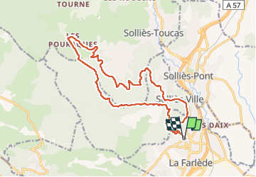

Length
21 km

Max alt
526 m

Uphill gradient
727 m
Km-Effort
31 km

Min alt
90 m

Downhill gradient
726 m
Boucle
Yes
Creation date :
2025-01-04 07:34:49.737
Updated on :
2025-01-04 17:18:43.56
7h41
Difficulty : Very difficult

FREE GPS app for hiking
 SityTrail
IGN / Geographical institutes
SityTrail Plus
The world is yours!
About
Trail Walking of 21 km to be discovered at Provence-Alpes-Côte d'Azur, Var, La Farlède. This trail is proposed by FSantoni.
Description
Une belle balade !
Photos


Positioning
Country:
France
Region :
Provence-Alpes-Côte d'Azur
Department/Province :
Var
Municipality :
La Farlède
Location:
Unknown
Start:(Dec)
Start:(UTM)
259391 ; 4783713 (32T) N.
Comments